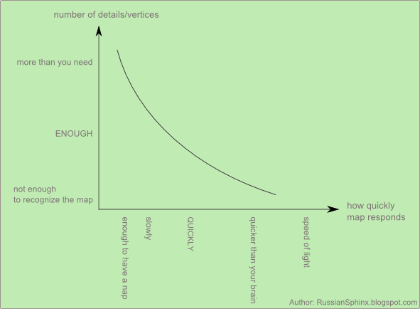
If your map works very slowly and you
have to wait for a respond for a loooooooooong time, it's a clear
sign that you need to simplify the geometries
of the shape files.
Polygons are drawn by joining vertices
by lines. Simplifying them means getting rid of some vertices. As you
can see on the image, it slightly changes
shape of the polygon.
Many shape files consists of
big number of
vertices presenting in details geography of administrative districts.
The problem's
that when you're working on data
visualizations with maps, not always you need so many details. Let's
say that you work on the map of the U.S. by states. The
users of your data visualization won't enlarge map to see on
their screens a few kilometre piece of the border
between two states. Even if the border on
detail level is a bit distorted there is no issue.
Your choice path looks like this:
Your choice path looks like this:
There may be some unwanted results of
simplifying such as gaps and overlaps. When you enlarge your map and
see something like this:
It means that you got them. There're some methods of dealing with them:
1) (If you're
a geographer, please don't read the following three sentences for health
reasons.) Total acceptance: I do have gaps and overlaps and I don't
mind, as they're visible only after
enlarging the map multiple
times.
This
is map of
Berlin which I used for one of my vizes, it's very small as it's just
a filter for other charts.
As you can see, the map hides a
dirty secret, it has gaps.
2) fixing the issue in GIS applications
3) using tools that don't produce gaps
and overlaps. I've
never had any issues with Map Shaper and SimpliPy (plug-in for QGIS) // Later I'll add here the link // .
If you use simplifying function in ShapeToTab you'll
always get gaps. Even if you're
anti gap still ShapeToTab's
fine in exporting to csv as you can simplify geometries
in Map Shaper or QGIS before you save it in csv in ShapeToTab.
I'm not a geographer I need to simplify
geometries of shape files for data visualizations with maps. In other
words I'm not a demanding user of simplifying tools lol. I realize
that I'm carefree with simplifying, geographers have harder task as
they have to work with many layers so they can't be so relaxed as me.


No comments:
Post a Comment